What is it?
"Distant" tells you where places are in relation to where you are now. It lists your places in order of distance, and colour codes them so that it is easy to tell at a glance whether you are getting closer or further away. It also tells you how long it will take to get there if you keep moving at the current speed. Places can be entered visually using Google Maps or directly by entering GPS co-ordinates.
What is it for?
Ever been on a long bus ride and wondered whether there are minutes or hours to go until you reach your destination? Ever had to negotiate with a cab driver who claimed that your destination was "very far away"? Once you got into the cab, did you wonder whether it was going in the right direction at all? Add a waypoint that represents your destination and track your progress in real time.
Going somewhere where you don't have mobile internet access or there is no coverage? Preload your waypoints while you still have access. Once this is done the app no longer requires data or even a signal. It works fine as long as you have a clear view of the sky and can get a GPS fix.
You can also use it to keep track of where you parked your car ...
What does it all mean?
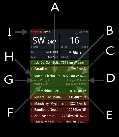
| A | The waypoint list. Any location that you mark goes into this list. Waypoints are kept sorted in order of distance and are shaded depending on whether they are getting closer (green), further away (red), or neither (yellow). |
| B | Distance between your current location and this waypoint. Also, the compass point you would have to head towards to get there. |
| C | Waypoints can have altitude data attached. If they do then this is the difference in height between you and the waypoint. The arrow indicates whether the waypoint is above or below you. |
| D | The speed at which you are getting closer or further away from this waypoint. This depends on your actual speed and your heading in relation to the waypoint. |
| E | Based on the relative speed (D) and the distance (B) this is an estimate of how long it would take to travel the distance to this waypoint. |
| F | The bearing that you would have to take to reach this waypoint. |
| G | To reach this waypoint you would need to correct your course according to what is listed here. |
| H | Waypoint order and name. |
| I | Location services accuracy bar. The smaller the number printed and the longer the bar the more accurately is your current location known. No GPS usually means that speed and direction will be unreported or useless. To get a GPS fix you will need a clear view of the sky - the more of it the better. Note that it may take some time to get the first GPS fix after a reboot of the phone although subsequent fixes will be a lot quicker. This is normal but varies considerably depending on the GPS hardware and radio firmware installed. |
To waypoint your current location.
Press the MENU button and select the "Add" menu item. The Waypoint Details screen will show a new waypoint at your current location. Change the name if you like and press "Save" icon.
To waypoint a different location.
Press the MENU button and select the "Map" menu item. Scroll the map to display the place you would like to waypoint. Press and hold on the exact spot; a menu will pop up. Select "new waypoint here" from the menu.
This is the Android version
Press here to see the Windows Phone version